Methods for Locating Property in Surety® & Surety® Pro
Locating an AOI [Area of Interest] can be achieved in a variety of convenient methods within the Surety® and Surety® Pro software.
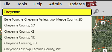
Multi Format Search Bar
Use the powerful dynamic search bar to search using a large number of different formats including:
- Address
- Example: 4200 James Ray Dr. Grand Forks, ND
- Section - Township – Range
- Example: 31-154N-67W
- Quarter & Lot Descriptions
- Example: S1/2NW1/4 14-151N-52W
- Can also include multiple descriptions in one search.
- Latitude and Longitude
- Compatible with different formats including: Decimal Degrees (DD.DDDD, DD.DDDD), Degrees-Minutes-Seconds (DD MM SS.SS), Degrees, Minutes (DD MM.MMMM)
- Township/Parish, County, and or City
- Example: Cass County, ND or Lake Township, IA
- Parcel Numbers
- Available with the Parcel Data Add-On in Surety and Surety Pro
Dedicated Search Panel
Surety® and Surety® Pro also offer a dedicated search panel that enables the ability to maintain previous search results on the map and offers more in depth search criteria including:
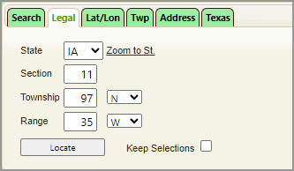
- Section Township Range
- Lat/Long
- Township/Parish and Section Number
- Physical Address
- Texas Blocks and Sections
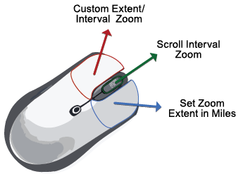
Map Navigation Tools
Surety® and Surety® Pro also provide tools to navigate the interactive map and feature a unique custom zoom extent tool when using a mouse or trackpad.
Land Resource Layers
Surety® and Surety® Pro offer a multitude of information overlays (layers) to add to the map to assist in locating an area of interest:
- Current and Historic FSA NAIP map imagery
- City and Town names
- Major and Minor Roads
- County Names
- Township Names
- Township and Range labels
- Sections
- Quarter Sections
- Quarter Quarter Sections
- Lots
- Parcel Numbers and Ownership Names (Available with Parcel Add-On)
Ownership Name Search (with Parcel Data Add-On)
Search by an owner name and generate results for an entire county. Select, Save, and/or zoom to the results.
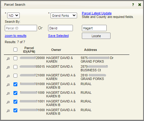
Note this feature is available to Surety® Pro accounts WITH the Parcel Data add-on.