
Field work management, land valuation, and asset management mapping software for the lower 48 US states and 2 canadian providences.
>> CLICK HERE TO SETUP YOUR FREE TRIAL <<
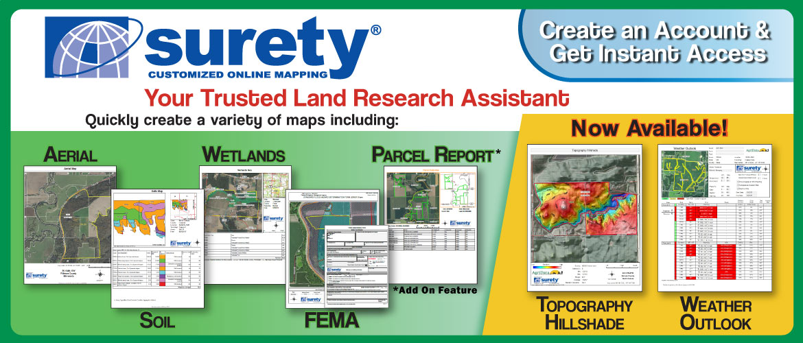
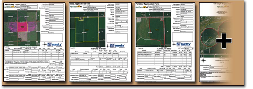
Produce Clear, Accurate, and Professional aerial imagery maps using the most up-to-date and historical FSA NAIP imagery. All maps include your company branding, mapped acres, and location data consisting of section information and map coordinates.
More Info...
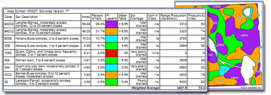
Access one of the most trusted and widely-used maps in the business. Our famous soil maps contain detailed information regarding soil composition conveniently organized by % of field. Display weighted averages of crop productivity values, soil class numbers, soil features such as drainage, water table depth, range production, septic limits and more. Our soil map will provide the appropriate productivity ratings automatically including: IA CSR & CSR2, Illinois Bulletin 811 Soil Productivity Index Ratings, MN, ND, SD, & OH Productivity Index (PI), NE SRPG, or NCCPI values.
More Info...
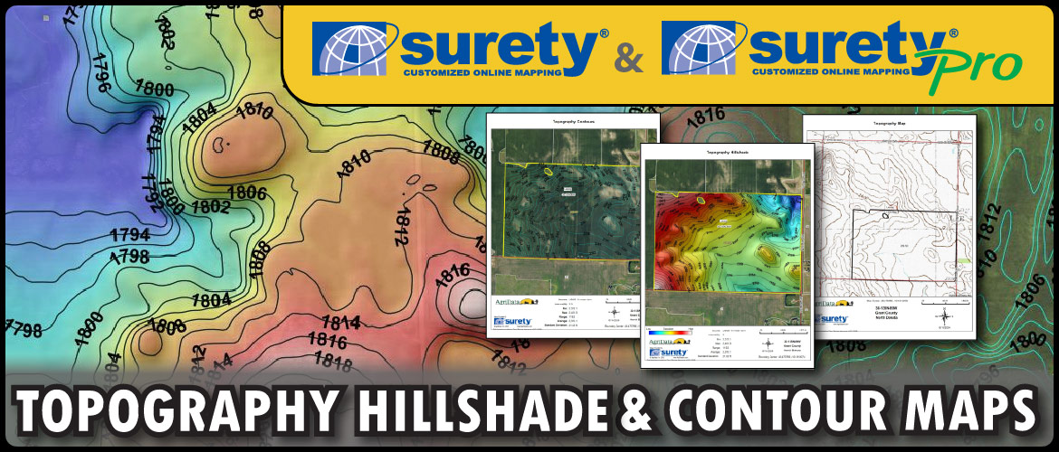
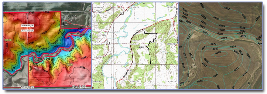
Topographical information plays a crucial role in land value assessment and agricultural practice. Surety® provides topographical information in a variety of ways. Adjust contour interval values to fit the area of interest, create a colorized hillshade map that is immediately understood, or create an original USGS topo map.
More Info...
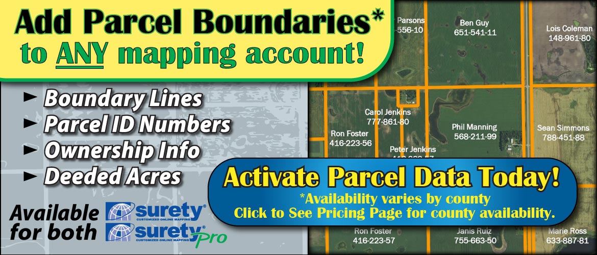
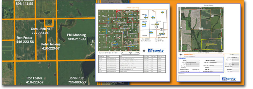
With over 98% of US parcel boundary coverage, the Parcel data layer includes mapped Parcel boundaries, Ownership names, Parcel Id, and more. Enhance your mapping accuracy by bringing the selected parcel information into a variety of maps and report templates. Parcel information is an add-on feature for both Surety® and Surety® Pro.
More Info...
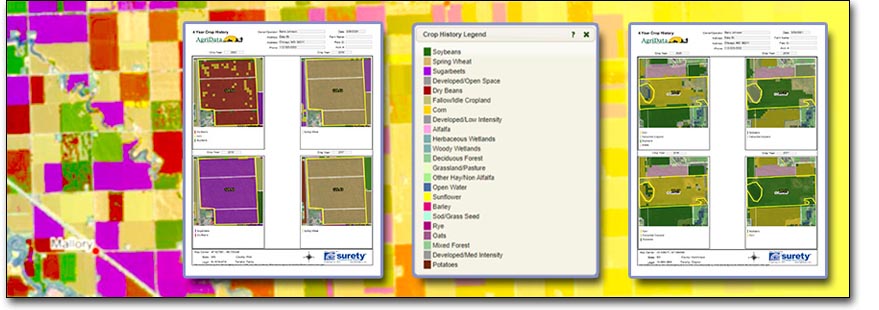
10+ years of crop history provided by the USDA Cropscape data layer. Display the crop history as a map layer or in a convenient 4-year report format.
More Info...
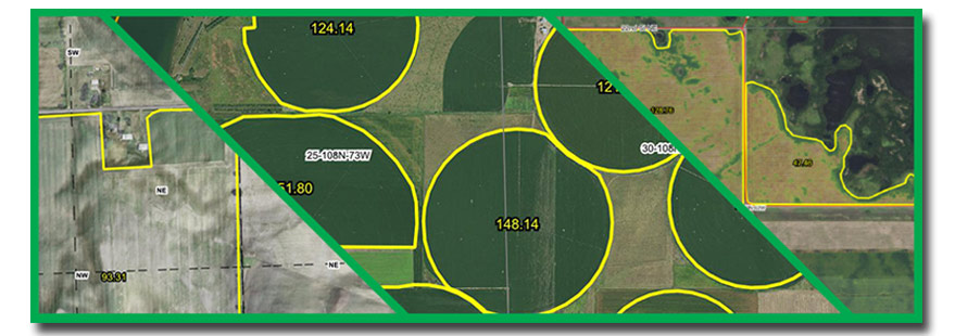
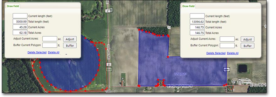
Quickly select existing FSA CLU boundaries(May 2008) or use our powerful drawing tools to adjust, merge, split, exclude, buffer, and outline areas on the map to create a boundary with precise acreage totals. These boundaries can be then used within Surety's extensive list of report and form templates or exported as a variety of file types to use in navigation systems or other mapping programs.
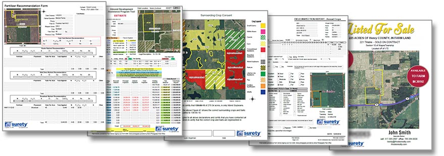
Try one of our standard application forms to document a variety of applications (chemical/fertilizer/seed/etc.) Fill in rates, convert measurement units, calculate totals, add log files, sum prices, document times, weather conditions and much more on one of our standard Application Forms or have us customize a form template to create the perfect integration of your current work process using our mapping technology.
More Info...
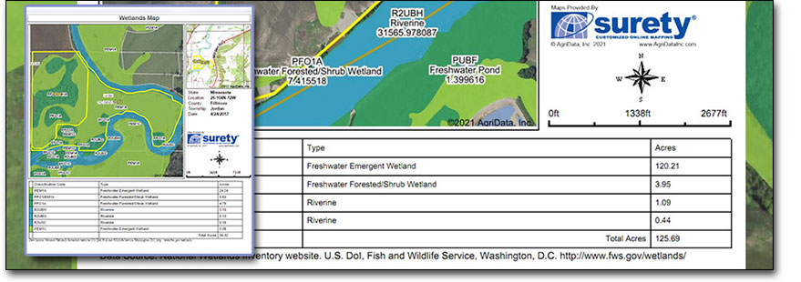
View the NRCS wetland designations within an area of interest. Produce an in-depth colorized map containing wetland classifications, wetland types, and acres within the area of interest.
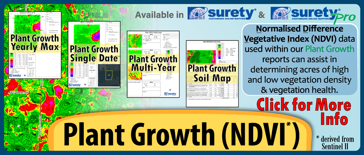
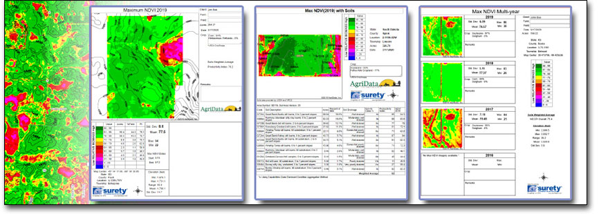
Utilizing the Normalized Difference Vegetation Index - a rating system for vegetation biomass using a near-infared and visible red reflectance to produce an index value - Surety® provides a variety of detailed report options to help determine crop and plant health. Reports include: Plant Growth by Year, Plant Growth Single Date, Plant Growth Soil Map, Plant Growth Multi-Year, and Plant Growth Hillshade.
More Info...
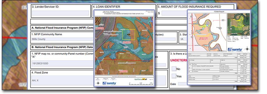
Quickly produce a FEMA dFIRM (digital Flood Insurance Rate Map) or a pre-filled FEMA Determination Map (FEMA 086-0-32) right alongside all the other maps you are already creating for your area of interest.
More Info...
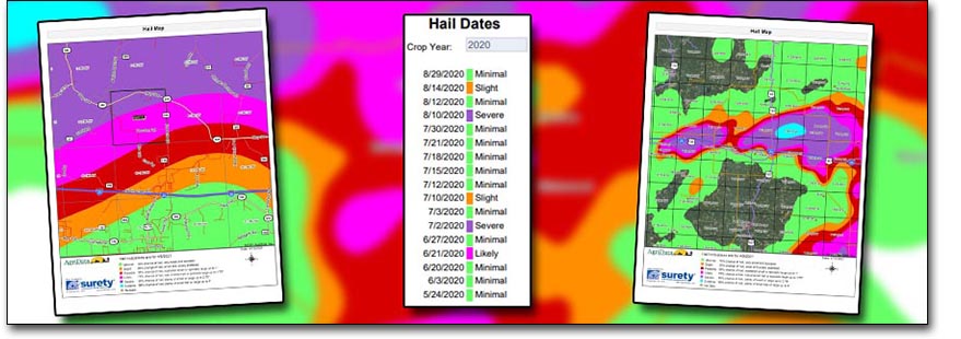
Stay on top of hail occurances with Surety® mapping's Hail probability data integration. Display hail occurrence probability as a Yearly report, single day report, or select a day to load the data layer on the interactive map.
Surety® Pro users have access to the automatic Hail Notification system. Receive notifications within 24 hours of a hail probability on your saved fields.
More Info...
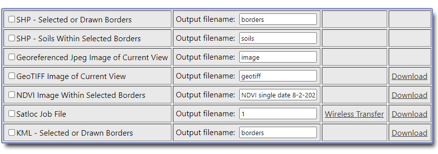
Download or e-mail your mapped boundaries as shapefiles, kmls, georeferenced jpegs, geotiffs, or Satloc® job files conveniently from one export interface. Surety® also offers a NDVI Geotiff imagery export directly from the NDVI reports.
More Info...
Already have an existing work order, sales sheet, or some other form template that you want to keep using? Submit a form template idea or a current template that you wish to reproduce and use within Surety® and our team of support professionals will build it right within your account for no extra charge.
More Info...
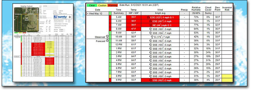
Surety® integrates with the best forecasting and historical weather database to bring even more use out of their mapping software. The Weather Outlook Map shows the Temperature, Wind speed and direction, precipitation chance, Relative Humidity, Cloud Cover, Dew Point and whether there is a temperature inversion risk on an hourly breakdown. Custom thresholds can be set to determine optimal or sub-optimal conditions for your application.